Written by Miocool Inc.
Get a Compatible APK for PC
| Download | Developer | Rating | Score | Current version | Adult Ranking |
|---|---|---|---|---|---|
| Check for APK → | Miocool Inc. | 550 | 4.62 | 2.8.20 | 4+ |
What is Map Plus? Map Plus is a powerful and versatile tool for viewing and editing custom maps, surveying, editing or managing mass of your geography or travel data. It can be used as a professional GIS tool for geographic data gathering, editing, measuring, cartography, surveying, planning, online/offline viewing and many other management. It can also be used to help your outdoor activities and global travels, for trip planning, offline map downloading, track/photo/video recording, or sharing memories with friends.
1. ● Many more fantastic and free functions could not be fully listed here, such as Guide Mark, Arrival Notification, Photo Mode, Map Level Adjust, Custom Icons, Photo/Video Attachments, Image Overlay, Text Overlay, Fast Editing, Distance/Perimeter/Area Measuring, Custom Time Zone, etc.
2. The most powerful and versatile tool for viewing and editing custom maps, surveying, editing or managing mass of your geography or travel data.
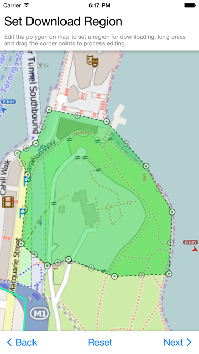
3. ● Supports importing, viewing and downloading thousands of custom online maps, such as OSM, GoogleMap, BingMap, USGS, or any WMS/WMTS map services.
4. ● You can use Map Plus as a professional GIS tool for geographic data gathering, editing, measuring, cartography, surveying, planning, online/offline viewing and many other management.
5. ● Importing and exporting KML/KMZ files with full styles, extended data and "gx" extension support.
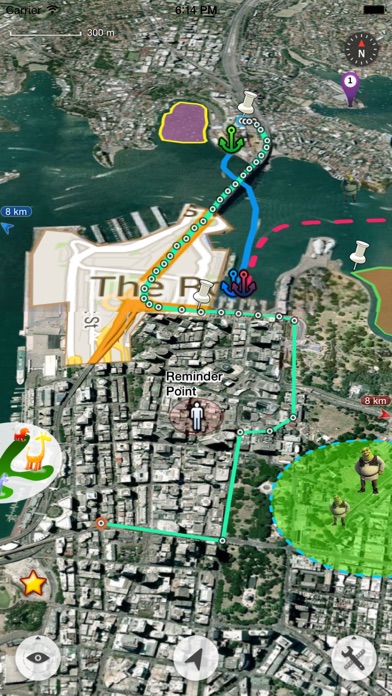
6. ● On-map Editing with Drag-Drop and Magnetic Snap support for all places, tracks, lines, polygons, circles, rectangles, text overlays, etc.
7. ● Browser Access enables you to upload and view data from a web browser on PC/Mac within a Wi-Fi network, or play slideshow on your TV for travel photos.
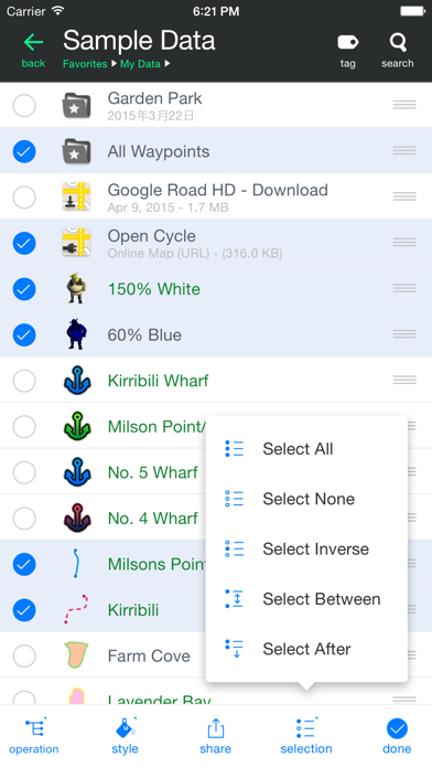
8. ● Managing mass data with multi-level folders, layers, bulk operations, shortcuts, tags and fuzzy searches.
9. ● Using Feature Class for bulk editing and managing on similar (same kind) features and layers all together.
10. ● Sharing or transferring data via Wi-Fi, Bluetooth, iCloud, SMS, Email, QR codes, Open-In, AirDrop or many other ways.
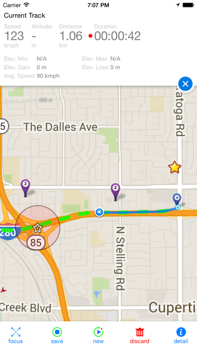
11. ● GPS Track Recording with auto-recovery, custom time zone and background mode support.
12. Liked Map Plus? here are 5 Navigation apps like Street Viewer plus; COTA Plus; Speed Trap Plus; CroPlus Web browser;
Not satisfied? Check for compatible PC Apps or Alternatives
| App | Download | Rating | Maker |
|---|---|---|---|
 map plus map plus |
Get App or Alternatives | 550 Reviews 4.62 |
Miocool Inc. |
Select Windows version:
Download and install the Map Plus app on your Windows 10,8,7 or Mac in 4 simple steps below:
To get Map Plus on Windows 11, check if there's a native Map Plus Windows app here » ». If none, follow the steps below:
| Minimum requirements | Recommended |
|---|---|
|
|
Map Plus On iTunes
| Download | Developer | Rating | Score | Current version | Adult Ranking |
|---|---|---|---|---|---|
| Free On iTunes | Miocool Inc. | 550 | 4.62 | 2.8.20 | 4+ |
Download on Android: Download Android
- Supports importing, viewing and downloading thousands of custom online maps, such as OSM, GoogleMap, BingMap, USGS, or any WMS/WMTS map services.
- Supports importing offline map files such as MBTiles.
- Supports both EPSG:4326 and Web Mercator (EPSG:3857) for raster maps; Supports offset maps using China GCJ-02 datum.
- Importing and exporting KML/KMZ files with full styles, extended data and "gx" extension support.
- Importing and exporting GIS vector files, such as SHP, TAB, GEOJSON, GML/GZ with all EPSG projections/CRS. (using GDAL)
- Importing/Exporting AutoCAD DXF files with blocks, mtext, xdata and affine transformation support for coordinates mapping.
- Importing files of CSV, GDB, MPS, WPT, EVT, PLT, PNT, RTE, etc.
- On-map Editing with Drag-Drop and Magnetic Snap support for all places, tracks, lines, polygons, circles, rectangles, text overlays, etc.
- GPS Track Recording with auto-recovery, custom time zone and background mode support.
- Path Following with voice guidance for own lines/tracks or searched out direction routes.
- Displaying photos and videos on the map based on locations.
- Managing mass data with multi-level folders, layers, bulk operations, shortcuts, tags and fuzzy searches. Advanced Search supports expressions and property conditions.
- Using Feature Class for bulk editing and managing on similar (same kind) features and layers all together. Supports bulk Attributes Merge and Link Relationship Building between features of different classes.
- Conditional Style, Script Property and Expression provide dynamic content of rendering, attributes and text labels.
- Customizable pop-up panel for selecting items on the map with HTML, JS and CSS support to make your own forms, layout and rich-formatted content.
- Displaying coordinates in MGRS or UTM.
- Photo Markup enables you to add arrows, texts, shapes, icons and free-hand draws to a photo.
- Browser Access enables you to upload and view data from a web browser on PC/Mac within a Wi-Fi network, or play slideshow on your TV for travel photos.
- Sharing or transferring data via Wi-Fi, Bluetooth, iCloud, SMS, Email, QR codes, Open-In, AirDrop or many other ways.
- Backup & Restore function helps you backup/restore data to/from files or iCloud easily.
- Many more fantastic and free functions such as Guide Mark, Arrival Notification, Photo Mode, Map Level Adjust, Custom Icons, Photo/Video Attachments, Image Overlay, Text Overlay, Fast Editing, Distance/Perimeter/Area Measuring, Custom Time Zone, etc.
- Includes a feature that reads tags from photos and plots them on a map
- Allows for layering of online maps and downloaded MBTiles
- Supports various projections and easy addition of GPX and shapefile layers
- Layering and drawing capabilities are more like a desktop app
- Great for dropping pin locations and attaching GPS-referenced photos
- Can be used offline and still allows drawing on maps
- Can track routes while offline
- No network needed file transfer from phone to phone
- Invaluable tool for field work and creating and sending .kmz files
- Line drawing functionality could be improved to be more organic and allow finger drawing
By far, the most advanced iOS mapping app.
Happy Geologist
Great app but takes some time to learn the interface
Field Surveying
 PC Apps