
Written by Zirak s.r.l.
Get a Compatible APK for PC
| Download | Developer | Rating | Score | Current version | Adult Ranking |
|---|---|---|---|---|---|
| Check for APK → | Zirak s.r.l. | 226 | 4.59734 | 11.4 | 4+ |
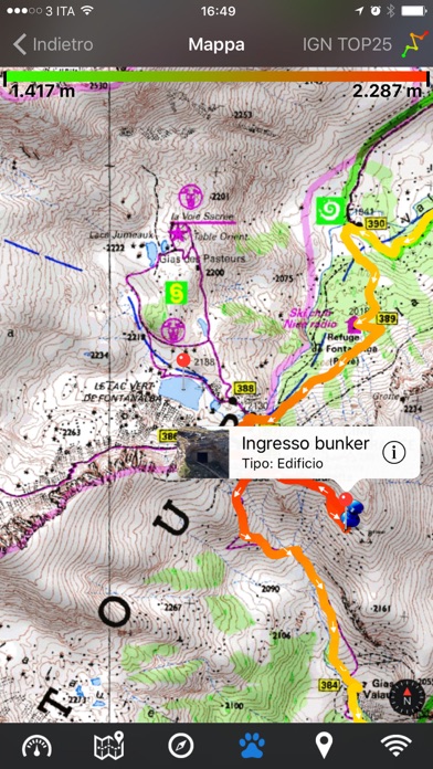
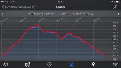

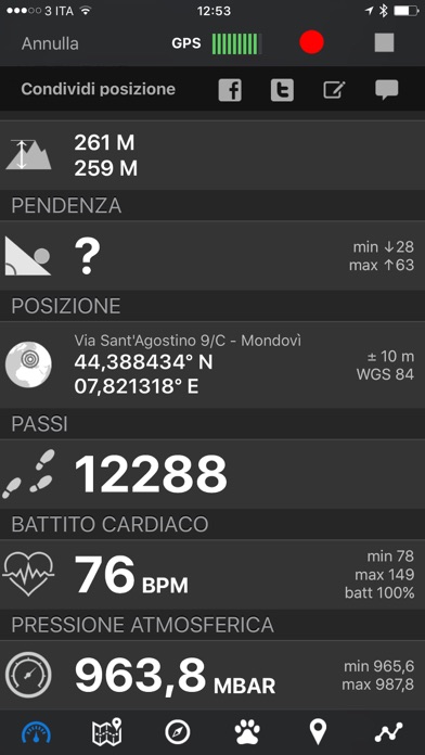
What is EasyTrails GPS? EasyTrails GPS is a GPS tracker application for iPhone that is perfect for outdoor activities and traveling. It allows users to track their distance, time, altitude, and other details in real-time on a map. The app also supports importing and sharing tracks, waypoints, photos, and ideas with friends. Users can share their GPS position on Facebook and Twitter and export their tracks in standard formats. EasyTrails GPS also supports navigation capabilities, custom cartography, and heart rate monitoring (with in-app purchase).
1. It's possible to import tracks by e-mail or Safari (EasyTrails can handle GPX, KML/KMZ and ZIP file formats), or by wi-fi networks, using an improved and easy to use web-based sharing feature.
2. Additionally, with the 'Colored tracks' in-app purchase, it will be possible to highlight heart rate data directly on the map screen of a recorded track.
3. Share where you are on Facebook and Twitter through your GPS position, and export your tracks in standard formats, so you can review them on Google Earth, SportTracks and TrailsRunner.
4. Additionally, EasyTrails GPS can communicate with navigators like Maps, Google Maps, TomTom or Waze (if installed) for more advanced guidance needs.
5. Are you going for a bike or motorcycle ride? Well, EasyTrails GPS will tell you how many miles you traveled, how much time you spent, how high you climbed and many other details.
6. We added the ability to connect to compatible Bluetooth heart rate monitors (such as Polar H6 and H7 devices).
7. You can import or share all tracks and waypoints, photos and ideas for new journeys with your friends.
8. Calculate routes and let EasyTrails guide you using the new navigation capabilities.
9. In real-time it will show you the course on a map, comparing it with downloaded tracks and points of interest.
10. Load custom cartography, EasyTrails supports KMZ and MBTILES formats.
11. It ensures the maximum duration of battery thanks to the possibility of recording in "StandBy" mode.
12. Liked EasyTrails GPS? here are 5 Sports apps like HuntStand: Maps, GPS & Tools; iGolf - GPS & Tee Times; Kingpin: Sports Betting Tips; SkyDroid - Golf GPS; Golf GPS SwingU;
Check for compatible PC Apps or Alternatives
| App | Download | Rating | Maker |
|---|---|---|---|
 easytrails gps easytrails gps |
Get App or Alternatives | 226 Reviews 4.59734 |
Zirak s.r.l. |
Select Windows version:
Download and install the EasyTrails GPS app on your Windows 10,8,7 or Mac in 4 simple steps below:
To get EasyTrails GPS on Windows 11, check if there's a native EasyTrails GPS Windows app here » ». If none, follow the steps below:
| Minimum requirements | Recommended |
|---|---|
|
|
EasyTrails GPS On iTunes
| Download | Developer | Rating | Score | Current version | Adult Ranking |
|---|---|---|---|---|---|
| $3.99 On iTunes | Zirak s.r.l. | 226 | 4.59734 | 11.4 | 4+ |
Download on Android: Download Android
- Track distance, time, altitude, and other details in real-time on a map
- Import and share tracks, waypoints, photos, and ideas with friends
- Share GPS position on Facebook and Twitter
- Export tracks in standard formats (GPX, KML/KMZ, CSV)
- Import tracks and waypoints (GPX, KML/KMZ)
- Resume recording of tracks
- Save waypoints with photos and descriptions
- Navigate to a point of interest
- Follow a path/track
- Navigate towards any waypoint or track marker
- Advanced navigation using any navigation app installed
- Upload tracks to GPSies, SportTracks, OpenTrail, OkMap
- Real-time visualization of distance, speed, altitude, bearing, and other data
- Map visualization in different modes (street map, satellite, hybrid, terrain)
- Charts (elevation profiles, etc.)
- Digital compass
- Heart rate monitoring (with in-app purchase)
- Turn-by-turn directions
- High battery duration (record in standby)
- Select between metric, imperial, and nautical measuring systems
- Intuitive and user-friendly interface
- Lightweight, reliable, and accurate
- Doesn't require an internet connection
- Supports different map types and coordinate systems
- Supports user-loaded offline cartography (KMZ, MBTILES)
- Privacy policy and terms of use available.
- Accurate mapping and navigation with near unlimited file size.
- Multi-format exports that work seamlessly with other software.
- Custom coordinate system option for GIS grade trail mapping and property reconnaissance.
- Useful for creating and sharing trails and waypoints with guests or for future planning.
- No specific cons mentioned in the review.
My “Go To” GPS app.
Very useful for my needs
Great app for hunters and outdoors people
Lives up to its name
 PC Apps